Manchester is a place where things happen. As the world’s first industrial city — and a titan of music, sport, art and politics — it’s somewhere with a global reputation. The list of iconic names associated with the city is long, from suffragette activist Emmeline Pankhurst, radical PM David Lloyd George and influential artist LS Lowry to the warring Gallagher brothers, football giants Manchester City (oh ok then, and United) and the legendary Hacienda nightclub.
The worker bee has been a local symbol since the 1840s, which says plenty about the Mancunian spirit — but this is not a destination resting on its past. A ‘transport revolution’ was recently announced for the city’s aptly named Bee Network, which will see an enlarged tram system, eight rail lines and potentially even an underground system. This comes on the back of high-profile openings that have included the National Trust’s Castlefield Viaduct — a Victorian-era viaduct reinvented as a ‘sky garden’ — as well as vast arts venues Co-Op Live and Aviva Studios.
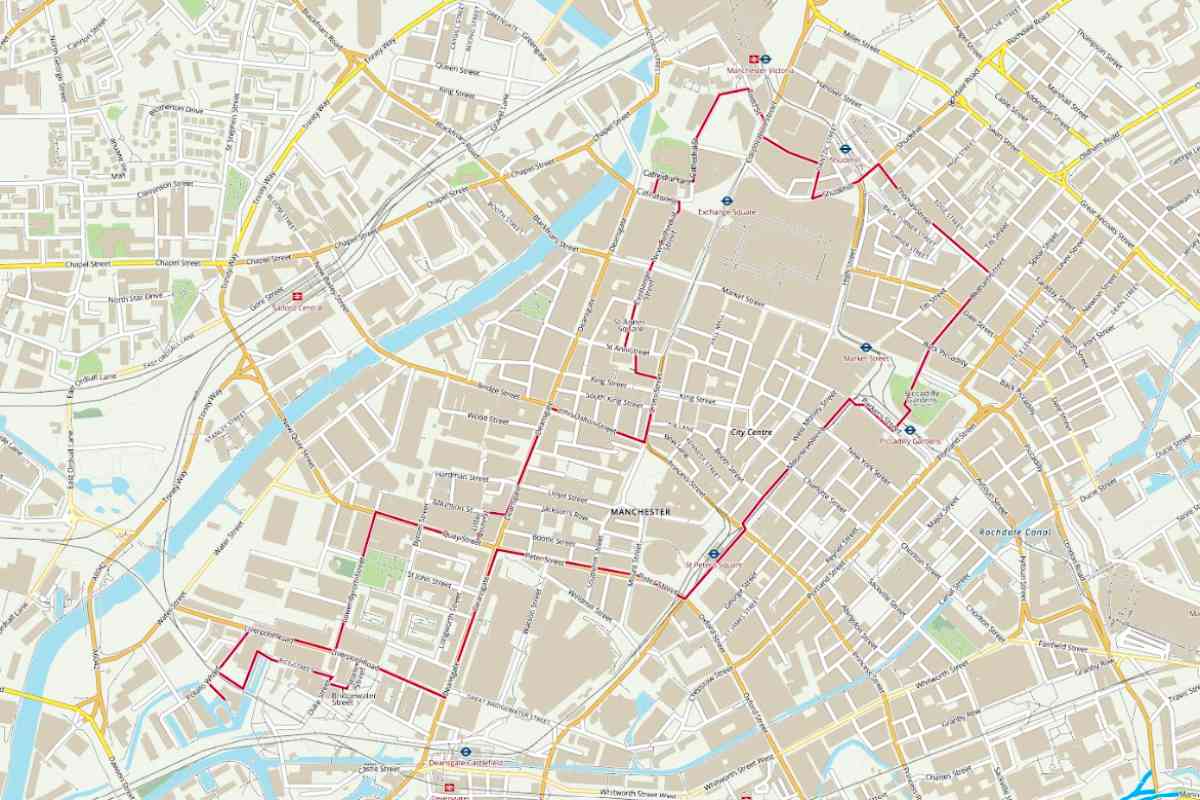
YHA Manchester, which sits in a heritage building on the canal-side, has recently expanded its offering with 17 new en suite rooms. The hostel also marks the approximate start and end point of the walk detailed here. The route takes in some of the city’s key sights and attractions — among them the Northern Quarter, the Museum of Science & Industry and the National Football Museum — readily serving up diversions for everyone from history nuts to hipsters.
The looped trail covers almost 3.5 miles and gives a great overview of what makes Manchester the place it is. The suggested duration is between 1 hour 15 minutes and 2 hours 15 minutes, but given how many sights you’ll encounter en route — and the number of quality cafés and pubs you’ll pass should you need refreshment — you could easily make a full day of it.
The attractions listed on the map areas follows:
- Science & Industry Museum,
- Manchester Opera House
- John Rylands Research Institute & Library
- Albert Square and Manchester Town Hall
- St Ann’s Church
- Royal Exchange Theatre
- Manchester Cathedral
- Corn Exchange
- Chetham’s Library
- National Football Museum
- The Printworks
- Arndale shopping centre
- Afflecks (independent shopping emporium)
- Piccadilly Gardens
- Manchester Art Gallery
- Alan Turing Memorial
- St Peter’s Square
- Manchester Central Library
- Bridgewater Hall, home of Halle Orchestra
- Manchester Central Convention Complex
- Castlefield Urban Heritage Park
- National Trust, Castlefield Viaduct
- Mamucium Roman Fort
- Castlefield Bowl
From the hostel turn R onto Potato Wharf, R onto Liverpool Road and L onto Lower Byrom Street. Turn R onto Quay Street, L onto Little Quay Street, R onto Atkinson Street and L onto Deansgate. Turn R onto John Dalton Street, L onto Cross Street, L onto St Ann’s Alley and follow around to the R onto St Ann Street. Continue ahead and to the L onto the pedestrianised St Ann’s Square, then onto Exchange Street and New Cathedral Street to Exchange Square. Turn L onto Cateaton Street and R through the alley (Hanging Bridge) next to the Cathedral Visitor Centre to Cathedral Yard. Turn R, L onto Cathedral Street, ahead alongside the Cathedral Gardens, bear R and then turn R onto Todd Street. Turn R onto Corporation Street, L to go through The Printworks and exit onto Dantzic Street. Turn R, L onto Shudehill, R onto Thomas Street (which becomes Hilton Street), then R onto Oldham Street and ahead across Piccadilly Gardens to Parker Street. Watch out for trams. Turn R, then L onto Mosley Street, head across St Peter’s Square and turn R by the Central Library onto Peter Street. Turn L onto Deansgate,
R onto Liverpool Road, L onto Stone Street, R onto Bridgewater Street, R onto Duke Street and L onto Rice Street to the canal. Head around the canal moorings and take the path next to the railway bridge to
Potato Wharf and turn L to the hostel.
This route has been created by YHA to provide inspiration and to aid planning and preparation of your walk. It doesn’t replace the need for an OS Map or the OS Maps App to navigate your walk safely. Digital maps are a guide and do not always reflect the conditions on the ground, ensure you are aware of your immediate surroundings.
Download this walking route and view the many other walking routes from YHA hostels. Our free, downloadable, self-guided maps are the perfect way to explore the surroundings of our beautiful hostels. Happy rambling.
Photo credit: Mylo Kaye / Unsplash
